Cycling through Senja & Andoya.
- Reidar A.

- Jul 5, 2019
- 8 min read
Updated: Apr 13, 2023
The idea to do this trip came from the youngest in the family - the one with at least some hours on a bicycle seat. In my case I have not done a lot of cycling the last couple of years, and I was cautiously anticipating both pain and open wounds. Luckily we did not plan very long daily stretches on this 6 day journey, so it should be ok?
While the neighbours got on the first all inclusive vacation to Greece, we set out on a different journey through some of the most beautiful landscape in the north. After a quick look on the weather forecast we even packed swim wear.

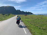
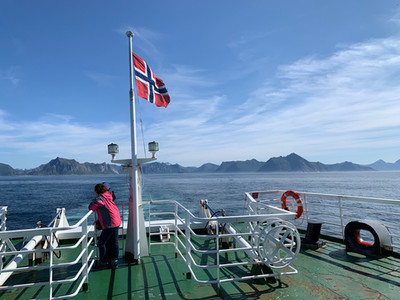
Day 1 - Tromsø to Lysnes on Senja (ferry ride).
The first stretch was only about 7 kilometres long - why overdo it on the first day. Some repacking and adjustmen, getting used to the 30 kg. behind the bike, and just getting in to character is always necessary when embarking on an adventure.
We got of the ferry at Lysnes - an hour from Tromso harbour. After a quick look at the map we started moving towards Senjahopen - a good 24km further vest.
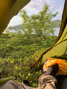
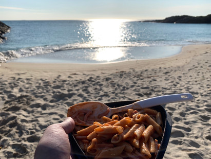
We found a suitable camping spot not far from Fjordbotn Camping, got the tents up - and got settled in with a Mack beer, some Real Turmat and Sørlandschips (one of the better potato chips).
Next leg goes from Fjordbotn to Senjahopen where we have to be before 3pm tomorrow to get some supplies for the next few days. Than the excursion moves towards one of the most spectacular beaches in Norway - stay tuned 😄


Day 2 - Toward the beach
Today started with a cup of coffee in the damp grass from quite a lot of rain during the night. Even though there was no rain forecasted, I always prepare for it - a good rule also in the winter with snow. Starting the day with wet gear would probably put a damper on the otherwise positive mood in the group 😉
I always find sleeping in a tent a bit difficult the first day - this night being kept awake by ravens, and of all things swans that was moving back and forth. The second day is usually a lot better (probably because the first night is not very good).
My sore “behind” predictions came through after almost 30km on the bike - I am just not used to moving this way anymore. Training a bit before even a relative short trip like this is probably a good idea.
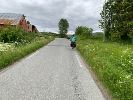
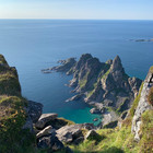
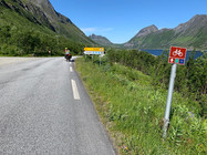
For those of you who don’t know Senja, the terrain is varied - to say the least. There is absolutely every terrain that is possible to cycle on - and of course a lot up and down. On an island with mountains there are naturally also a lot of tunnels, the longest today was Geitskaret with its 2,2km. The county of Berg, that we went through most if the day today, have spend some resources on making the tunnels safer by putting up warning lights that are activated by pressing a button to indicate that you are in the tunnel. All in all it has felt like a safe ride today, even with cars passing by on roads a lot more narrow than we are used to.
Our goal today was to get to the shop in Senjahopen before 3pm : 26 km later, and maybe an hour overdue for lunch - check on that!
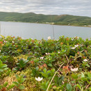
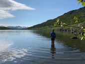
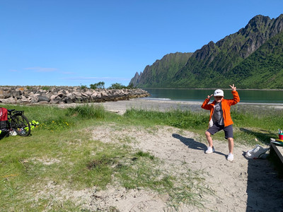
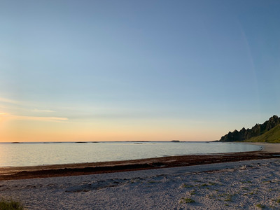
Right now in Ersfjorden, about 5 km from Senjahopen. Probably one if the most spectacular beaches, at least in the north of Norway. Surrounded by 700-800m.a.s.l high mountains, Okshornan (the devils teeth) are the most famous with it’s 6 pointy peaks looking like the mouth of a dragon. Another sightseeing would be the golden toilet - when constructed one of the most expensive toilets in Norway 😄.

Trying to mentally prepare myself and the family to go two rather long mountain climbs tomorrow - we should get to Finnsæter on the northern part of the island by the end of the day. Moskitos are back - time to seek shelter in the tent!


Day 3 - Highest point on the journey
Today was a long day on the road with several highlights and challenges. I had to relive my son of his gel seat as the parts of my body in contact with the seat was getting more sore than I like. It was heaven! My best tip after day three you ask - do not save money on the 250 NOK gel seat.
We had prepared to do two rather steep mountain climbs, and were positively surprised when the first one from the beach in Steinfjorden was an easy few kilometers. The second climb was sadly just as hard as predicted, with a view point half way overlooking Bergsbotn. A nice place to get some lunch before going the last 4km to the top, containing the 1894m long Skaland tunnell. This one is uphill the whole way, going through the second highest mountain on the island, Stormoa with its 974m.a.s.l.*
Hard challenges usually come with sweet rewards, this time in the form of a quiet mountain lake with a small beach. We could not get in to the water and “swimming” fast enough - with some soap even the more sweaty of us smelled like pine trees and spring.
After a nice 4,5km downhill and another 6 by the coast we ended up for dinner by the old churchyard at Finnsæter. The churchyard used to be part of the nikel mining community being operated between 1872 - 1886 by a Wales based company called Vivian & Sons. This is of course a story on its own - even today you can see some of the buildings that was not dismantled after they abandoned the mining.Something to remember for the next quiz - Norways, and maybe the first ever hydroelectric power plant was build here.
After an ice cream at the (worlds largest, but now burned down!) Senja troll, we ended up at yet another beach at Ballesvika an hour later. After a quick late night snack, the kids begged us to go in the sleeping bags - it had been a long day. There are not many evenings like this during a summer in the north, important to enjoy while it lasts 🏖
*the highest mountain on Senja is the 1017m.a.s.l. Breitind, close to Mefjordbotn on the norther part of Senja.


Senja facts
Senja is the second largest island in Norway. The island had 7,864 inhabitants as of 1 January 2017. Most of the residents live along the eastern coast of the island, with Silsand, close to the mainland “capital” of Finnsnes, being the largest urban area on the island. The fishing village of Gryllefjord on the west coast has a summer-only ferry connection to the nearby island of Andøya - the one we hope to be on in a couple of day.
Day 4 - Gryllefjord & Bleik
Woke up to yet a beautiful morning, on yet another beach, with yet another fantastic view... It’s true! Even though the water temperature is nothing to write long books about, the beaches are stunning - and there is a new one around almost every corner we turn.
Anyway - after a short breakfast we got on our bikes and headed for Gryllefjord about 6 km away. The tunnel through Småtinden is only 1km long, going downhill. Without the pram behind the bike I am pretty sure i could have rolled all the way to the quay ,where the 11 pm ferry took us over to Andoya - a 1,5hour ferry ride operated during the summer. Getting to Andenes, the “capital” of Andoya I followed my day three advise and bought myself a gel seat to protect the family jewels. Giving back the one I borrowed from my son, I am now expecting grandchildren within the next 20-25.
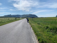
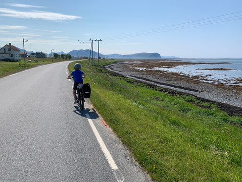
Cycling from Andenes to Bleik* is an easy 10km flat ride through Game of thrones/Lord of the rings terrain - on good roads. This is a spectacular part of the trip on its own, but remember I told you about the beaches on Senja? The beaches on Andoya are out of this world - you have to see them to believe me. They even have a 9-hole golf course here, open 24/7 during the midnight sun season. I did not go for a dip in the water- 8 degrees could be a threat to my masculinity.
The day ended with a trip to Måtinden, only a few kilometers from Blake. Nice hike with an old army buddy of mine whom I told 20 years ago I would come visit. The walk it self was about 8 km, the view an easy top 5 - and that competition is fierce, as we have all ready established.
The night is spent at Midnattsol Camping in a tent - tomorrow we will have to work on our 48km stretch in to Risøyhamn where we will grab the Hurtigruten back home.
*The name Bleik is from old norse, meaning pale- or white skin.


Day 5 - Last day/leaving the mountains
The summer in the north has been nice to us on these adventures days, reasonable warm weather and not much wind. Two weeks prior it was snowing at 200m.a.s.l - (you can read about it here).
Waking up at the Midnattsol camping- we had an easy morning. Three cups of (nice and tasty) camping coffee later we headed out towards our longest stretch. Roughly 50km between Bleik and Risøyhamn where we where supposed to meet the Hurtigruten ship MS Kong Harald. After about 5km we left the mountains behind - flat and nice all the way to the camping at Stave where we enjoyed an ice-cream at the Stave camping & hot pool. An hour later we made a stop at Nordmela for lunch. Can’t help not loving these smaller grocery stores that are not part of the big chains. They have something unique about them - a place to get everything from fishing gear to freshly baked bread and a cup if coffee. We enjoyed the hospitality, and had fuel to continue south.
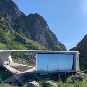
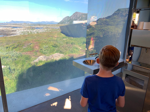
Børhella is part of a project called Nasjonale turistveier - a viewpoint and a cultural treasure in Bukkekjerka near by. There is a futuristic construction by the road that contains toilets with a view. It seems that it is only possible to have a look at the surroundings from the inside. In the distance and to the vest there is Anda fyr - the northern most part of Vesterålen. Børrvågen was a lively fishing village up until 1879, when «the storm» destroyed all the houses. It was never rebuildt, but it is possible to find remains after the people who spent their life here.
We had plenty of time to get to Risøyhamn, and on a tip we made a stop at Børvågen to get some beach time before heading to our end destination. Even though I did not dip my masculine body in the 8 degrees water, both Iver and Karin decided it was a good idea to test their hypothermia abilities. Well, they did survive - only to discover that the sand on the beach had a nasty tendency to stick to skin in a way where you had to pick every single grain away manually.
A nasty wind from the north brought us back on the road, and in the direction of Nøss, Bø and Bjørnskinn. We made a stop at Marmelkroken B&B out of curiosity, and ended up with a glass of South African whine, pancakes and cold whole milk from the farm next door. An experience we probably would have missed out on if we came in a car. Slow and curious also brought us to an old village from the iron ages - another nice break.


Risøyhamn, where we would meet our ship, was getting closer - the ride was coming to an end. When cycling over the flat areas pass the Sørmela directional sign, one could reflect a bit - on how lucky we are to be able to do this, how well everything went, health, weather, sore behinds and all the things one normally reflects upon after an adventure of this proportion. A flat tire on the pram 8km from our goal was peanuts in the big picture.
Thanks for a nice ride!


Comments